


Garmin dezl LGV720

 Installment calculator
4,9%
interest
from 227,- monthly
Installment calculator
4,9%
interest
from 227,- monthly

Garmin dezl LGV720

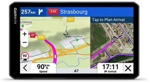
The 7″ dēzl LGV720 satellite navigation system offers important dēzl community features to make life on the road easier for professional truck drivers. Get insights on parking, loading docks and preferred truck locations based on ratings from fellow drivers. The 7″ high-resolution display offers unparalleled clarity and readability for the important data you need to keep track of while driving. You can also control the dēzl navigation by voice for greater safety when driving (available in English, French, German, Italian, Spanish, Danish, Swedish and Dutch. ). Dēzl offers confidence on the move with map updates and detailed street maps of Europe. Plus, if you download the dēzl™ app, you can access up-to-date traffic, weather and fuel price information.

Key features of the Garmin GPS navigation system LGV720
- Bright 7″ high-resolution touchscreen
- Route calculation tailored to your vehicle
- Advanced Arrival Planning with Aerial View
- Voice assistant
- Reviews from other truck drivers in the dēzl community
- Works with GPS and GALLIELEO sensors
- BirdsEye Direct satellite images
- Wind speed warning for hazardous conditions
- Other truck drivers' favourite routes
- Compatible with rear camera
- MicroSD slot
Easy journey planning
With the ability to calculate a route based on the truck profile, you can simply enter the dimensions, weight or transport of hazardous materials and the navigation will offer you preferred routes suitable for your vehicle and load. When planning your arrival, you'll appreciate BirdsEye Direct's satellite imagery, which displays an overhead view of loading docks, entrances or security gates to ensure smooth transit to your location. You can also join the dēzl community, where you can find recommended truck parks, rate your experiences and share tips with other drivers.

Wind warnings and low emission zones
Navigation displays an overlay layer with wind speed and weather information directly on the map, giving you early warning of potentially dangerous conditions or high winds along the route. Also included is warning and guidance on entering low emission zones, allowing you to plan your route efficiently and with the current constraints in each city in mind.

Advanced navigation functions
The navigation offers information from the Truck Parking Europe© database to help you quickly find suitable parking along your route, and allows you to plan your breaks efficiently with timely announcements of journey times. Handy driver alerts let you know when sharp corners, steep gradients or speed changes are approaching. There's also travel information with Tripadvisor® reviews for hotels, restaurants and attractions along the route. The navigation is easy to use thanks to the voice assistant, which is available in several European languages.

Display and memory options
Navigation offers a large 6.95" widescreen IPS display with capacitive touchscreen and on-cell technology for exceptional image sensitivity and clarity. The display measures 15.2 × 8.9 cm and has a high resolution of 1024 × 600 pixels,providing a sharp and detailed image in all conditions. The device is powered by a powerful rechargeable lithium-ion battery that lasts up to 1.5 hours. There's 32GB of internal memory and the option to expand the storage with a microSD card (not included), making it convenient to add more maps and data.


Connected functions
Navigation offers connected features to simplify your journey. Thanks to integrated Wi-Fi®, you can easily update maps and software without a computer. Download the dēzl™ app to get up-to-date information on traffic, weather and fuel prices right on the go. You can sync the navigation with a compatible smartphone and use the hands-free function for safe phone calls while driving. When paired with the app, the navigation display also shows text messages and other smart notifications to keep you informed without losing focus on the road.
Specifications
Dimensions
Weight
Navigation type
Hardware and Software
Battery life and memory
Equipment and features
Maps
Languages
Color and finish
Package contents

Garmin Würzburg GmbH, Leightonstraße 7, 97074 Würzburg, Německo, www.garmin.com, [email protected]
Specifications can be changed without notice. Images are for illustrative purposes only.